
Thank you for supporting this site ❤️
Make a donation
Make a donation
Medford topographic map
Click on the map to display elevation.
Thank you for supporting this site ❤️
Make a donation
Make a donation
About this map
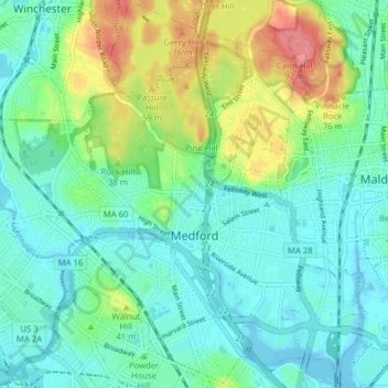
Name: Medford topographic map, elevation, terrain.
Average elevation: 23 m
Minimum elevation: -5 m
Maximum elevation: 85 m
Thank you for supporting this site ❤️
Make a donation
Make a donation
Other topographic maps
Click on a map to view its topography, its elevation and its terrain.
Arlington Heights
United States > Massachusetts > Middlesex County > Arlington > Arlington Heights
Average elevation: 58 m