
Make a donation
Stikine Region topographic map
Click on the map to display elevation.
Make a donation
About this map
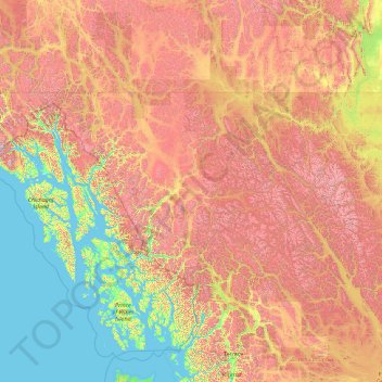
Name: Stikine Region topographic map, elevation, terrain.
Location: Stikine Region, British Columbia, Canada (56.00000 -139.06133 60.00193 -124.45114)
Average elevation: 886 m
Minimum elevation: -3 m
Maximum elevation: 3,558 m
Make a donation
Other topographic maps
Click on a map to view its topography, its elevation and its terrain.
Treasure Mountain
Canada > British Columbia > Regional District of Okanagan-Similkameen > Area H (Manning Park/Tulameen/Siwash)
Average elevation: 1,448 m
Ernest Lake
Canada > British Columbia > Thompson-Nicola Regional District > Area L (Grasslands)
Average elevation: 1,260 m
Nagas Point
Canada > British Columbia > North Coast Regional District > Area E (Moresby Island)
Average elevation: 4 m
Make a donation
McMurdo
Canada > British Columbia > Columbia-Shuswap Regional District > Area A (Kicking Horse/Kinbasket Lake)
Average elevation: 852 m
East Pine
Canada > British Columbia > Peace River Regional District > Area E (Moberly Lake/Sukunka Valley)
Average elevation: 664 m