
Weißkirchen an der Traun topographic map
Interactive map
Click on the map to display elevation.
About this map
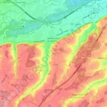
Name: Weißkirchen an der Traun topographic map, elevation, terrain.
Location: Weißkirchen an der Traun, Bezirk Wels-Land, 4616, Österreich (48.12413 14.08836 48.18761 14.17117)
Average elevation: 340 m
Minimum elevation: 278 m
Maximum elevation: 393 m
Weißkirchen an der Traun liegt auf 305 m Höhe im Hausruckviertel. Die Ausdehnung beträgt von Nord nach Süd 6,2 km, von West nach Ost 7,1 km. Die Gesamtfläche beträgt 21,8 km².
Other topographic maps
Click on a map to view its topography, its elevation and its terrain.
Neukirchen bei Lambach
Neukirchen bei Lambach, Bezirk Wels-Land, 4671, Österreich
Average elevation: 408 m
Inn
Österreich > Bezirk Wels-Land > Pichl bei Wels
Inn, Pichl bei Wels, Bezirk Wels-Land, 4632, Österreich
Average elevation: 344 m
Lambach
Lambach, Bezirk Wels-Land, 4650, Österreich
Average elevation: 378 m
Pichl bei Wels
Pichl bei Wels, Bezirk Wels-Land, Oberösterreich, 4632, Österreich
Average elevation: 375 m
Steinhaus
Steinhaus, Bezirk Wels-Land, 4641, Österreich
Average elevation: 379 m