
Thank you for supporting this site ❤️
Make a donation
Make a donation
Etter topographic map
Click on the map to display elevation.
Thank you for supporting this site ❤️
Make a donation
Make a donation
About this map
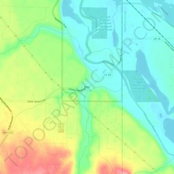
Name: Etter topographic map, elevation, terrain.
Average elevation: 233 m
Minimum elevation: 200 m
Maximum elevation: 290 m
Thank you for supporting this site ❤️
Make a donation
Make a donation
Other topographic maps
Click on a map to view its topography, its elevation and its terrain.
Chimney Rock Scenic and Natural Area
United States > Minnesota > Dakota County
Average elevation: 269 m
Thank you for supporting this site ❤️
Make a donation
Make a donation
Thank you for supporting this site ❤️
Make a donation
Make a donation
Pig's Eye Island Heron Rookery SNA
United States > Minnesota > Dakota County > South St. Paul
Average elevation: 221 m