
Thank you for supporting this site ❤️
Make a donation
Make a donation
Vedder River topographic map
Click on the map to display elevation.
Thank you for supporting this site ❤️
Make a donation
Make a donation
About this map
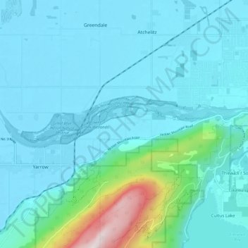
Name: Vedder River topographic map, elevation, terrain.
Average elevation: 110 m
Minimum elevation: 2 m
Maximum elevation: 856 m
Thank you for supporting this site ❤️
Make a donation
Make a donation
Other topographic maps
Click on a map to view its topography, its elevation and its terrain.
Minto Landing
Canada > British Columbia > Fraser Valley Regional District > Chilliwack
Average elevation: 19 m
Vedder Mountain
Canada > British Columbia > Fraser Valley Regional District > Chilliwack
Average elevation: 556 m
Rosedale
Canada > British Columbia > Fraser Valley Regional District > Chilliwack
Average elevation: 23 m
Elk Mountain
Canada > British Columbia > Fraser Valley Regional District > Chilliwack
Average elevation: 1,009 m
Thank you for supporting this site ❤️
Make a donation
Make a donation