
Thank you for supporting this site ❤️
Make a donation
Make a donation
Tackaberry Lake topographic map
Click on the map to display elevation.
Thank you for supporting this site ❤️
Make a donation
Make a donation
About this map
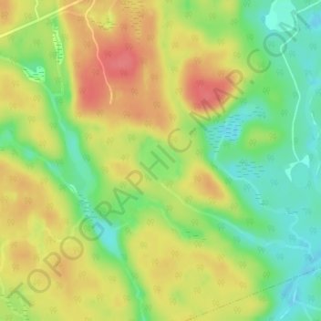
Name: Tackaberry Lake topographic map, elevation, terrain.
Average elevation: 338 m
Minimum elevation: 304 m
Maximum elevation: 370 m
Thank you for supporting this site ❤️
Make a donation
Make a donation
Other topographic maps
Click on a map to view its topography, its elevation and its terrain.
Limberlost Forest and Wildlife Reserve
Canada > Ontario > Muskoka District > Lake of Bays Township
Average elevation: 400 m