
Thank you for supporting this site ❤️
Make a donation
Make a donation
Waha topographic map
Click on the map to display elevation.
Thank you for supporting this site ❤️
Make a donation
Make a donation
About this map
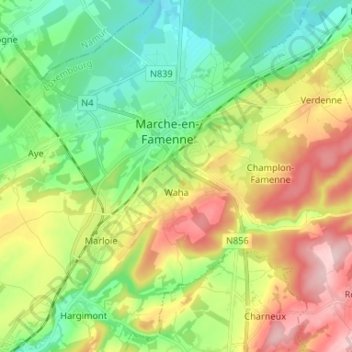
Name: Waha topographic map, elevation, terrain.
Location: Waha, Marche-en-Famenne, Luxembourg, Wallonie, 6900, Belgique (50.18752 5.29357 50.24413 5.42491)
Average elevation: 265 m
Minimum elevation: 178 m
Maximum elevation: 408 m
Thank you for supporting this site ❤️
Make a donation
Make a donation
Other topographic maps
Click on a map to view its topography, its elevation and its terrain.
Marche-en-Famenne
Belgique > Luxembourg > Marche-en-Famenne > Marche-en-Famenne
Average elevation: 252 m