
Thank you for supporting this site ❤️
Make a donation
Make a donation
Lake Crescent topographic map
Click on the map to display elevation.
Thank you for supporting this site ❤️
Make a donation
Make a donation
About this map
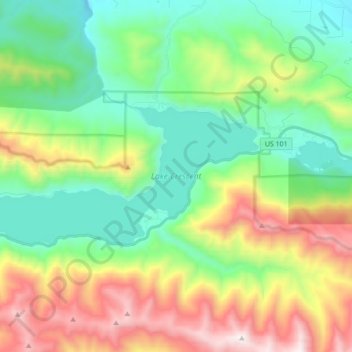
Name: Lake Crescent topographic map, elevation, terrain.
Location: Lake Crescent, Clallam County, Washington, United States (48.04896 -123.91599 48.09473 -123.74224)
Average elevation: 564 m
Minimum elevation: 71 m
Maximum elevation: 1,543 m
Thank you for supporting this site ❤️
Make a donation
Make a donation
Other topographic maps
Click on a map to view its topography, its elevation and its terrain.
Thank you for supporting this site ❤️
Make a donation
Make a donation
Sekiu
United States > Washington > Clallam County
Sekiu Airport is located a mile west of Sekiu and offers a 2,997-foot (913 m) lighted runway with a visual approach indicator, at an elevation of 350 feet (110 m).
Average elevation: 59 m
Thank you for supporting this site ❤️
Make a donation
Make a donation
Thank you for supporting this site ❤️
Make a donation
Make a donation
Thank you for supporting this site ❤️
Make a donation
Make a donation
Thank you for supporting this site ❤️
Make a donation
Make a donation
Thank you for supporting this site ❤️
Make a donation
Make a donation