
Thank you for supporting this site ❤️
Make a donation
Make a donation
Karangpoh topographic map
Click on the map to display elevation.
Thank you for supporting this site ❤️
Make a donation
Make a donation
About this map
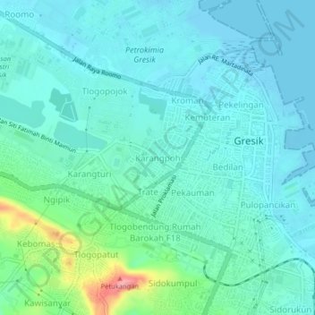
Name: Karangpoh topographic map, elevation, terrain.
Location: Karangpoh, Gresik, East Java, 61116, Indonesia (-7.17935 112.62431 -7.13935 112.66431)
Average elevation: 20 m
Minimum elevation: 0 m
Maximum elevation: 109 m
Thank you for supporting this site ❤️
Make a donation
Make a donation
Other topographic maps
Click on a map to view its topography, its elevation and its terrain.