
Thank you for supporting this site ❤️
Make a donation
Make a donation
Gömeç topographic map
Click on the map to display elevation.
Thank you for supporting this site ❤️
Make a donation
Make a donation
About this map
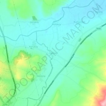
Name: Gömeç topographic map, elevation, terrain.
Location: Gömeç, Kastamonu, Black Sea Region, 37200, Turkey (41.41532 33.80130 41.45532 33.84130)
Average elevation: 732 m
Minimum elevation: 692 m
Maximum elevation: 860 m
Thank you for supporting this site ❤️
Make a donation
Make a donation
Other topographic maps
Click on a map to view its topography, its elevation and its terrain.