
Thank you for supporting this site ❤️
Make a donation
Make a donation
Zweifall topographic map
Click on the map to display elevation.
Thank you for supporting this site ❤️
Make a donation
Make a donation
Zweifall
Zweifall ligt aan de Vichtbach bij de samenvloeiing met de Hasselbach, op een hoogte van 253 meter. Het wordt omringd door bossen, en de bosbouw is dan ook een belangrijke tak van bedrijvigheid. Er zijn natuurleerpaden en een uitzichtpunt boven het dal.
Thank you for supporting this site ❤️
Make a donation
Make a donation
About this map
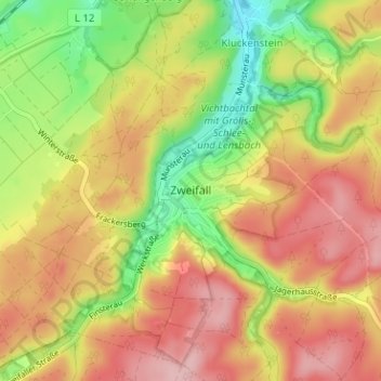
Name: Zweifall topographic map, elevation, terrain.
Average elevation: 306 m
Minimum elevation: 223 m
Maximum elevation: 374 m
Thank you for supporting this site ❤️
Make a donation
Make a donation