
Thank you for supporting this site ❤️
Make a donation
Make a donation
McKinney topographic map
Click on the map to display elevation.
Thank you for supporting this site ❤️
Make a donation
Make a donation
About this map
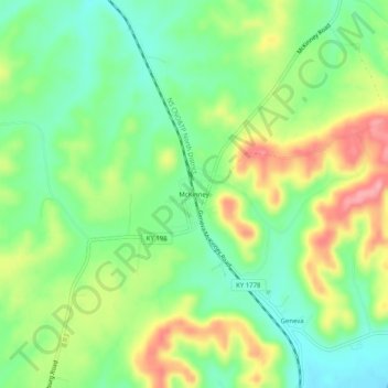
Name: McKinney topographic map, elevation, terrain.
Location: McKinney, Lincoln County, Kentucky, 40448, United States (37.43258 -84.77911 37.47258 -84.73911)
Average elevation: 323 m
Minimum elevation: 277 m
Maximum elevation: 391 m
Thank you for supporting this site ❤️
Make a donation
Make a donation
Other topographic maps
Click on a map to view its topography, its elevation and its terrain.
William Whitley State Historic House
United States > Kentucky > Lincoln County
Average elevation: 284 m