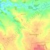
Diss topographic map
Click on the map to display elevation.
About this map

Name: Diss topographic map, elevation, terrain.
Location: Diss, Norfolk, England, United Kingdom (52.36686 1.09587 52.38685 1.13158)
Average elevation: 35 m
Minimum elevation: 22 m
Maximum elevation: 49 m
Other topographic maps
Click on a map to view its topography, its elevation and its terrain.



Ringstead
United Kingdom > England > Norfolk > King's Lynn and West Norfolk > Ringstead
Average elevation: 37 m

Beacon Hill
United Kingdom > England > Norfolk > North Norfolk
Beacon Hill is a part of the Cromer Ridge which is a ridge of old glacial moraines (terminal moraine) that stands next to the coast above Cromer. The Cromer Ridge seems to have been the front line of the ice sheet for some time at the last glaciations, which is shown by the large size of the feature. All the…
Average elevation: 65 m

Wymondham
United Kingdom > England > Norfolk > South Norfolk
Wymondham's topography is marked by its river meadow and flat, low-lying agricultural landscape, much like the rest of East Anglia. The parish has an area of 17.11 square miles (44.31 km2). The geology is based on chalk, with a layer of boulder clay laid down in the last ice age. The River Tiffey, flowing…
Average elevation: 43 m


Southery
United Kingdom > England > Norfolk > King's Lynn and West Norfolk > Southery
Average elevation: 0 m

Walsingham
United Kingdom > England > Norfolk > North Norfolk
The River Stiffkey flows through the parish, from south to north, passing to the east of bulk of the village. The centre of Little Walsingham is at an elevation of around 17 metres (56 ft) and lies within the Stiffkey valley, with the land rising to the east and west — to the west it rises to around 75…
Average elevation: 43 m


Brettenham Heath - Open Access Land
United Kingdom > England > Norfolk > Breckland District > Brettenham
Average elevation: 40 m










St John's Fen End
United Kingdom > England > Norfolk > King's Lynn and West Norfolk
Average elevation: 1 m


Weasenham All Saints
United Kingdom > England > Norfolk > Breckland District > Weasenham
Average elevation: 71 m


Brandon Bank
United Kingdom > England > Norfolk > King's Lynn and West Norfolk > Feltwell
Average elevation: -1 m




Grimston
United Kingdom > England > Norfolk > King's Lynn and West Norfolk > Grimston
Average elevation: 30 m




Newgate
United Kingdom > England > Norfolk > North Norfolk > Cley next the Sea > Newgate
Average elevation: 22 m




Dersingham
United Kingdom > England > Norfolk > King's Lynn and West Norfolk > Dersingham
Average elevation: 29 m


Downham Market
United Kingdom > England > Norfolk > King's Lynn and West Norfolk
Average elevation: 20 m


Terrington St. Clement
United Kingdom > England > Norfolk > King's Lynn and West Norfolk
Average elevation: 2 m


Burnham Market
United Kingdom > England > Norfolk > King's Lynn and West Norfolk
Average elevation: 44 m