
Thank you for supporting this site ❤️
Make a donation
Make a donation
Wermutshausen topographic map
Click on the map to display elevation.
Thank you for supporting this site ❤️
Make a donation
Make a donation
About this map
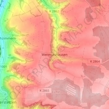
Name: Wermutshausen topographic map, elevation, terrain.
Average elevation: 419 m
Minimum elevation: 272 m
Maximum elevation: 476 m
Thank you for supporting this site ❤️
Make a donation
Make a donation
Other topographic maps
Click on a map to view its topography, its elevation and its terrain.
Rüsselhausen
Deutschland > Baden-Württemberg > Main-Tauber-Kreis > Niederstetten
Average elevation: 338 m
Adolzhausen
Deutschland > Baden-Württemberg > Main-Tauber-Kreis > Niederstetten
Average elevation: 420 m
Wermutshausen
Deutschland > Baden-Württemberg > Main-Tauber-Kreis > Niederstetten
Average elevation: 413 m