
Udaipur topographic map
Click on the map to display elevation.
Udaipur
Udaipur is located at 23°32′N 91°29′E / 23.53°N 91.48°E / 23.53; 91.48. It has an average elevation of 22 meters (72 feet)from the sea level. The Gomati river passes through the heart of Udaipur and helps in irrigation of its lands.
About this map
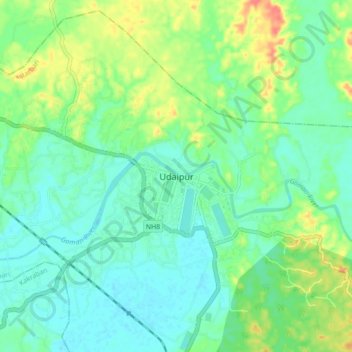
Name: Udaipur topographic map, elevation, terrain.
Location: Udaipur, Matarbari, Udaipur, Gomati, Tripura, 799120, India (23.50162 91.45176 23.58162 91.53176)
Average elevation: 33 m
Minimum elevation: 16 m
Maximum elevation: 70 m