
Thank you for supporting this site ❤️
Make a donation
Make a donation
Regné topographic map
Click on the map to display elevation.
Thank you for supporting this site ❤️
Make a donation
Make a donation
About this map
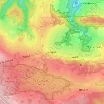
Name: Regné topographic map, elevation, terrain.
Location: Regné, Vielsalm, Bastogne, Luxembourg, Wallonia, 4990, Belgium (50.23361 5.76919 50.27361 5.80919)
Average elevation: 536 m
Minimum elevation: 417 m
Maximum elevation: 616 m
Thank you for supporting this site ❤️
Make a donation
Make a donation
Other topographic maps
Click on a map to view its topography, its elevation and its terrain.