
Thank you for supporting this site ❤️
Make a donation
Make a donation
Gulf Park Estates topographic map
Click on the map to display elevation.
Thank you for supporting this site ❤️
Make a donation
Make a donation
About this map
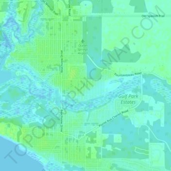
Name: Gulf Park Estates topographic map, elevation, terrain.
Average elevation: 5 m
Minimum elevation: -7 m
Maximum elevation: 12 m
Thank you for supporting this site ❤️
Make a donation
Make a donation
Other topographic maps
Click on a map to view its topography, its elevation and its terrain.
Marine Education Center
United States > Mississippi > Jackson County > Ocean Springs
Average elevation: 4 m
Thank you for supporting this site ❤️
Make a donation
Make a donation
Ocean Springs
United States > Mississippi > Jackson County > Ocean Springs > Ocean Springs
Average elevation: 4 m
Grand Bay Natural Wildlife Refuge
United States > Mississippi > Jackson County > Moss Point
Average elevation: 3 m
Thank you for supporting this site ❤️
Make a donation
Make a donation