
Thank you for supporting this site ❤️
Make a donation
Make a donation
Northampton Parish topographic map
Click on the map to display elevation.
Thank you for supporting this site ❤️
Make a donation
Make a donation
About this map
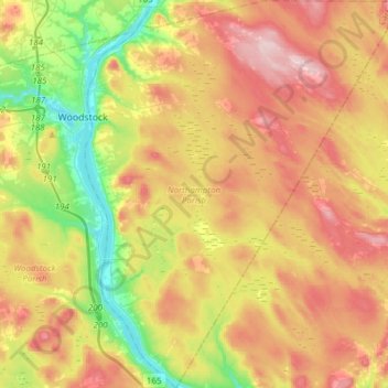
Name: Northampton Parish topographic map, elevation, terrain.
Location: Northampton Parish, Carleton County, New Brunswick, Canada (46.00208 -67.57177 46.21368 -67.32105)
Average elevation: 156 m
Minimum elevation: 35 m
Maximum elevation: 286 m
Thank you for supporting this site ❤️
Make a donation
Make a donation
Other topographic maps
Click on a map to view its topography, its elevation and its terrain.
South Knowlesville
Canada > New Brunswick > Carleton County > Town of Hartland
Average elevation: 285 m