
Make a donation
Montpothier topographic map
Click on the map to display elevation.
Make a donation
Montpothier
Plusieurs études ont été menées afin de caractériser les types climatiques auxquels est exposé le territoire national. Les zonages obtenus diffèrent selon les méthodes utilisées, la nature et le nombre des paramètres pris en compte, le maillage territorial des données et la période de référence. En 2010, le climat de la commune était ainsi de type climat océanique dégradé des plaines du Centre et du Nord, selon une étude du Centre national de la recherche scientifique (CNRS) s'appuyant sur une méthode combinant données climatiques et facteurs de milieu (topographie, occupation des sols, etc.) et des données couvrant la période 1971-2000. En 2020, le climat prédominant est classé Cfb, selon la classification de Köppen-Geiger, pour la période 1988-2017, à savoir un climat tempéré à été frais sans saison sèche. Par ailleurs Météo-France publie en 2020 une nouvelle typologie des climats de la France métropolitaine dans laquelle la commune est exposée à un climat océanique altéré et est dans la région climatique Nord-est du bassin Parisien, caractérisée par un ensoleillement médiocre, une pluviométrie moyenne régulièrement répartie au cours de l’année et un hiver froid (3 °C). Elle est en outre dans la zone H1b au titre de la réglementation environnementale 2020 des constructions neuves.
Make a donation
About this map
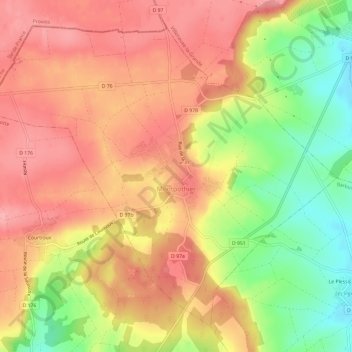
Name: Montpothier topographic map, elevation, terrain.
Average elevation: 138 m
Minimum elevation: 74 m
Maximum elevation: 179 m
Make a donation
Other topographic maps
Click on a map to view its topography, its elevation and its terrain.
Make a donation
Make a donation
Make a donation
Make a donation
Troyes
France > Grand Est > Aube > Troyes
La superficie de la commune de Troyes est de 1 320 ha quand la superficie moyenne communale en France métropolitaine s'établit à 1 505,8 ha ; son altitude varie de 100 m, au niveau de la Seine à la limite entre Troyes et Barberey-Saint-Sulpice, à 126 m au sud-ouest, à la limite du territoire communal de…
Average elevation: 151 m
Fontaine-Mâcon
France > Grand Est > Aube > Fontaine-Mâcon > Fontaine-Mâcon
Fontaine-Mâcon est une commune située dans le département de l'Aube (région de Champagne-Ardenne), à la limite avec l'Yonne et la Seine-et-Marne. La ville de Fontaine-Mâcon appartient au canton de Nogent-sur-Seine et à l'arrondissement de Nogent-sur-Seine. Les habitants de Fontaine-Mâcon s'appellent…
Average elevation: 93 m
Make a donation
Make a donation
Make a donation
Make a donation
Make a donation
Make a donation
Make a donation
Make a donation
Make a donation
Make a donation
Make a donation
Anse de Jolivet
France > Grand Est > Aube > Lusigny-sur-Barse > Les Hautes Bones
Average elevation: 135 m
Make a donation
Le Mineroy Chalois
France > Grand Est > Aube > Aix-Villemaur-Pâlis > Aix-en-Othe
Average elevation: 216 m
Les Loges
France > Grand Est > Aube > Saint-Hilaire-sous-Romilly > La Noue des Rois
Average elevation: 68 m
Make a donation
Make a donation
Make a donation
Make a donation
Make a donation
Pont-sur-Seine
France > Grand Est > Aube > Pont-sur-Seine > Pont-sur-Seine
Située sur la rive gauche de la Seine, à une altitude de 71 m environ, la commune présente une superficie voisine de 16 km2.
Average elevation: 78 m
Make a donation
Montfey
France > Grand Est > Aube > Montfey > Montfey
Le village où se trouve la mairie, se trouve au sommet d'un coteau, à 173 mètres d'altitude, d'où l'on a un vaste panorama sur la campagne environnante où alternent vastes champs, boqueteaux, vallons et coteaux boisés, hameaux. Il est traversé par la D 22, par la D 90 et par le sentier de randonnée «…
Average elevation: 147 m
Montceaux-lès-Vaudes
France > Grand Est > Aube > Montceaux-lès-Vaudes > Montceaux-lès-Vaudes
Average elevation: 136 m
Saint-Benoist-sur-Vanne
France > Grand Est > Aube > Saint-Benoist-sur-Vanne > Saint-Benoist-sur-Vanne
Average elevation: 158 m
Make a donation
Make a donation
Ferreux-Quincey
France > Grand Est > Aube > Ferreux-Quincey > Ferreux-Quincey
Average elevation: 119 m
Beauvoir-sur-Sarce
France > Grand Est > Aube > Bragelogne > Beauvoir-sur-Sarce
Average elevation: 263 m
Make a donation