
Thank you for supporting this site ❤️
Make a donation
Make a donation
Palmyra topographic map
Click on the map to display elevation.
Thank you for supporting this site ❤️
Make a donation
Make a donation
About this map
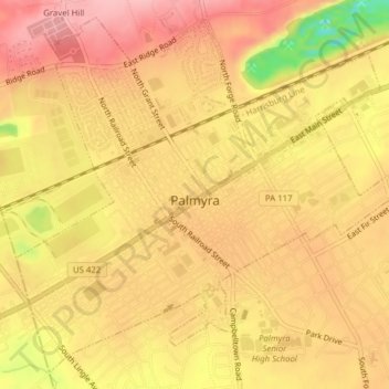
Name: Palmyra topographic map, elevation, terrain.
Location: Palmyra, Lebanon County, Pennsylvania, United States (40.29561 -76.61113 40.32279 -76.57232)
Average elevation: 140 m
Minimum elevation: 48 m
Maximum elevation: 184 m
Thank you for supporting this site ❤️
Make a donation
Make a donation
Other topographic maps
Click on a map to view its topography, its elevation and its terrain.
Sunset
United States > Pennsylvania > Lebanon County > North Lebanon Township
Average elevation: 180 m
Fort Indiantown Gap
United States > Pennsylvania > Lebanon County > Union Township
Average elevation: 217 m
Lights Dam
United States > Pennsylvania > Lebanon County > North Lebanon Township > Ebenezer
Average elevation: 168 m
Woodfort
United States > Pennsylvania > Lebanon County > North Cornwall Township
Average elevation: 144 m
Thank you for supporting this site ❤️
Make a donation
Make a donation