
Thank you for supporting this site ❤️
Make a donation
Make a donation
Shutesbury topographic map
Click on the map to display elevation.
Thank you for supporting this site ❤️
Make a donation
Make a donation
About this map
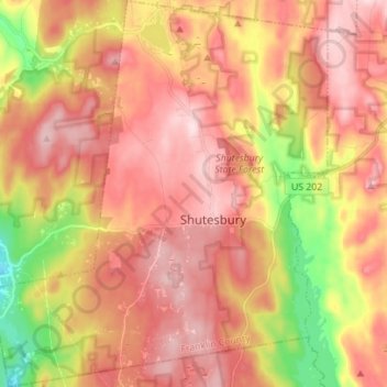
Name: Shutesbury topographic map, elevation, terrain.
Average elevation: 281 m
Minimum elevation: 106 m
Maximum elevation: 394 m
Thank you for supporting this site ❤️
Make a donation
Make a donation
Other topographic maps
Click on a map to view its topography, its elevation and its terrain.
Thank you for supporting this site ❤️
Make a donation
Make a donation
Rocky Mountain Park
United States > Massachusetts > Franklin County > Greenfield > Greenfield
Average elevation: 68 m
Thank you for supporting this site ❤️
Make a donation
Make a donation
Baconville
United States > Massachusetts > Franklin County > Sirius Community
Average elevation: 306 m
Buckland Four Corners
United States > Massachusetts > Franklin County > Buckland
Average elevation: 346 m
Thank you for supporting this site ❤️
Make a donation
Make a donation
Louisiana Mountain
United States > Massachusetts > Franklin County > Northfield
Average elevation: 205 m