
Thank you for supporting this site ❤️
Make a donation
Make a donation
Rainaskot topographic map
Click on the map to display elevation.
Thank you for supporting this site ❤️
Make a donation
Make a donation
About this map
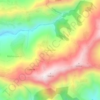
Name: Rainaskot topographic map, elevation, terrain.
Location: Rainaskot, Rainas, Lamjung, Gandaki Province, Nepal (28.11242 84.47251 28.15242 84.51251)
Average elevation: 1,200 m
Minimum elevation: 726 m
Maximum elevation: 1,660 m
Thank you for supporting this site ❤️
Make a donation
Make a donation
Other topographic maps
Click on a map to view its topography, its elevation and its terrain.