
Thank you for supporting this site ❤️
Make a donation
Make a donation
Nordend Ost topographic map
Click on the map to display elevation.
Thank you for supporting this site ❤️
Make a donation
Make a donation
About this map
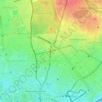
Name: Nordend Ost topographic map, elevation, terrain.
Location: Nordend Ost, Innenstadt 3, Frankfurt, Hesse, 60316, Germany (50.11574 8.68876 50.13916 8.70636)
Average elevation: 128 m
Minimum elevation: 101 m
Maximum elevation: 163 m
Thank you for supporting this site ❤️
Make a donation
Make a donation
Other topographic maps
Click on a map to view its topography, its elevation and its terrain.