
Thank you for supporting this site ❤️
Make a donation
Make a donation
Whitley Bay topographic map
Click on the map to display elevation.
Thank you for supporting this site ❤️
Make a donation
Make a donation
About this map
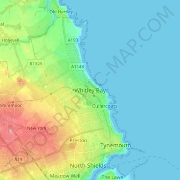
Name: Whitley Bay topographic map, elevation, terrain.
Average elevation: 21 m
Minimum elevation: -1 m
Maximum elevation: 81 m
Thank you for supporting this site ❤️
Make a donation
Make a donation
Other topographic maps
Click on a map to view its topography, its elevation and its terrain.
Smith's Dock
United Kingdom > England > Tyne and Wear > North Tyneside > North Shields
Average elevation: 21 m