
Thank you for supporting this site ❤️
Make a donation
Make a donation
Wildwood topographic map
Click on the map to display elevation.
Thank you for supporting this site ❤️
Make a donation
Make a donation
About this map
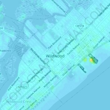
Name: Wildwood topographic map, elevation, terrain.
Location: Wildwood, Cape May County, New Jersey, 08260, United States (38.97420 -74.83512 38.99878 -74.79960)
Average elevation: 1 m
Minimum elevation: -4 m
Maximum elevation: 28 m
Thank you for supporting this site ❤️
Make a donation
Make a donation
Other topographic maps
Click on a map to view its topography, its elevation and its terrain.