Geolocate

Cajamarca topographic map

Click on the map to display elevation.

Cajamarca

Cajamarca (Spanish pronunciation: [kaxaˈmaɾka]; Quechua: Kashamarka; Aymara: Qajamarka) is a department and region in Peru. The capital is the city of Cajamarca. It is located in the north part of the country and shares a border with Ecuador. The city has an elevation of 2,700 metres (8,900 ft) above sea level in the Andes Mountain Range, the longest mountain range in the world. Part of its territory includes the Amazon Rainforest, the largest in the world.

Wikipedia (CC-BY-SA 3.0)

About this map

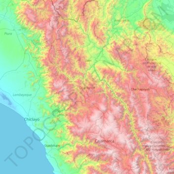
Name: Cajamarca topographic map, elevation, terrain.

Location: Cajamarca, Peru (-7.76346 -79.45845 -4.62395 -77.74130)

Average elevation: 1,456 m

Minimum elevation: -4 m

Maximum elevation: 4,585 m

Other topographic maps

Click on a map to view its topography, its elevation and its terrain.

Chiu Chiu

Peru > Lima > Barranca

Average elevation: 181 m

Province of Canchis

Peru > Cusco

Average elevation: 3,832 m

Vista Alegre

Peru > Junín > Tarma

Average elevation: 3,287 m

Vinicunca

Peru > Cusco > Cusipata

Vinicunca, or Winikunka, also called Montaña de Siete Colores (literally: Mountain of seven colors), Montaña de Colores (Mountain of colors) or Montaña Arcoíris (Rainbow Mountain), is a mountain in the Andes of Peru with an altitude of 5,200 metres (17,100 ft) above sea level. It is located on the road to…

Average elevation: 4,874 m

Artesonraju

Peru > Ancash > Santa Cruz

Average elevation: 5,138 m

Ceresa Pampa

Peru > Huánuco > Quisqui > Huancapallac

Average elevation: 2,725 m

Durazno Pata

Peru > Ayacucho > Huanta

Average elevation: 2,574 m

Huacapampa

Peru > Ancash > Huaraz

Average elevation: 3,215 m

Fundo Pucuri

Peru > Ica > Montesierpe

Average elevation: 479 m

Department of Amazonas

Peru > Amazonas

Average elevation: 928 m

Mendoza

Peru > Ica

Average elevation: 127 m

Lindero

Peru > Ica > Palpa > Saramarca

Average elevation: 896 m

Santa Fe

Peru > Loreto > Emilio San Martín

Average elevation: 103 m

Catamarca

Peru > Arequipa > Tisco

Average elevation: 4,229 m

Constitutional Province of Callao

Peru

Average elevation: 1,009 m

Province of Bolognesi

Peru > Ancash

Average elevation: 3,102 m

Province of Caylloma

Peru > Arequipa

Average elevation: 3,696 m

Province of Lauricocha

Peru > Huánuco

Average elevation: 3,393 m

Province of Huancavelica

Peru > Huancavelica

Average elevation: 3,583 m

Province of Yungay

Peru > Ancash

Average elevation: 2,668 m

Province of Urubamba

Peru > Cusco

Average elevation: 2,937 m

Carcas

Peru > Ancash > Chiquián > Carcas

Average elevation: 3,533 m

Los Angeles

Peru > Tacna > Los Angeles

Average elevation: 948 m

Symbols

Peru > Ica > San Francisco > entrada al ingenio

Average elevation: 555 m

Urubamba

Peru > Cusco

Average elevation: 2,970 m

Monkey

Peru > Ica > San Miguel de la Pascana

Average elevation: 454 m

Santiago de Vado

Peru > Ayacucho > Lucanas

Average elevation: 3,379 m

San Miguel de la Pascana

Peru > Ica

Average elevation: 406 m