
Thank you for supporting this site ❤️
Make a donation
Make a donation
Grand Port topographic map
Click on the map to display elevation.
Thank you for supporting this site ❤️
Make a donation
Make a donation
About this map
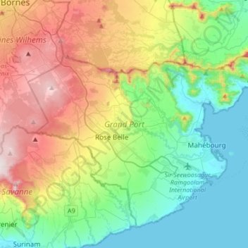
Name: Grand Port topographic map, elevation, terrain.
Location: Grand Port, Mauritius (-20.49533 57.51077 -20.28418 57.78114)
Average elevation: 244 m
Minimum elevation: 0 m
Maximum elevation: 715 m
Thank you for supporting this site ❤️
Make a donation
Make a donation