
Thank you for supporting this site ❤️
Make a donation
Make a donation
Pesanggaran topographic map
Click on the map to display elevation.
Thank you for supporting this site ❤️
Make a donation
Make a donation
About this map
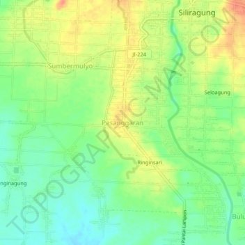
Name: Pesanggaran topographic map, elevation, terrain.
Location: Pesanggaran, Banyuwangi, East Java, Java, Indonesia (-8.59356 114.07800 -8.55356 114.11800)
Average elevation: 21 m
Minimum elevation: 1 m
Maximum elevation: 43 m
Thank you for supporting this site ❤️
Make a donation
Make a donation
Other topographic maps
Click on a map to view its topography, its elevation and its terrain.