
Make a donation
Peniel topographic map
Click on the map to display elevation.
Make a donation
About this map
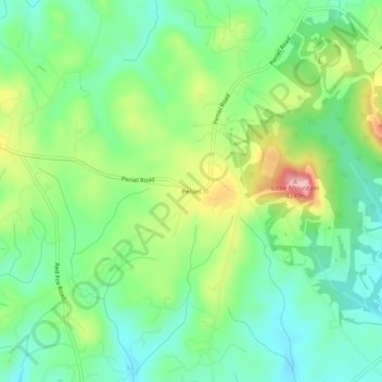
Name: Peniel topographic map, elevation, terrain.
Location: Peniel, Polk County, North Carolina, 28722, United States (35.21650 -82.15733 35.25650 -82.11733)
Average elevation: 326 m
Minimum elevation: 274 m
Maximum elevation: 425 m
Make a donation
Other topographic maps
Click on a map to view its topography, its elevation and its terrain.
Tryon
United States > North Carolina > Polk County
The elevation of the town is 1,067 feet (325 m) above sea level. The town's original boundary was established as a circle with a radius of three quarters of a mile. According to the United States Census Bureau, the town has a total area of 1.8 square miles (4.7 km2), all land.
Average elevation: 333 m
Saluda
United States > North Carolina > Polk County
Saluda is located in southwestern Polk County at 35°14′16″N 82°20′49″W / 35.237856°N 82.346870°W / 35.237856; -82.346870 (35.237856, -82.346870). Two small parts of the city extend west and north into Henderson County. The elevation on Main Street is 2,097 feet (639 m) above sea level,…
Average elevation: 635 m
Make a donation
Tryon
United States > North Carolina > Polk County
The elevation of the town is 1,067 feet (325 m) above sea level. The town's original boundary was established as a circle with a radius of three quarters of a mile. According to the United States Census Bureau, the town has a total area of 1.8 square miles (4.7 km2), all land.
Average elevation: 333 m
Saluda
United States > North Carolina > Polk County
Saluda is located in southwestern Polk County at 35°14′16″N 82°20′49″W / 35.237856°N 82.346870°W / 35.237856; -82.346870 (35.237856, -82.346870). Two small parts of the city extend west and north into Henderson County. The elevation on Main Street is 2,097 feet (639 m) above sea level,…
Average elevation: 635 m