
Les Haudères topographic map
Interactive map
Click on the map to display elevation.
About this map
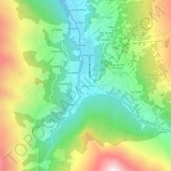
Name: Les Haudères topographic map, elevation, terrain.
Location: Les Haudères, Evolène, Hérens, Valais/Wallis, 1983, Zwitserland (46.06270 7.48757 46.10270 7.52757)
Average elevation: 1,877 m
Minimum elevation: 1,368 m
Maximum elevation: 2,731 m
Other topographic maps
Click on a map to view its topography, its elevation and its terrain.
Mont Blanc de Cheilon
Zwitserland > Valais/Wallis > Hérens > Hérémence
Mont Blanc de Cheilon, Hérémence, Hérens, Valais/Wallis, 1987, Zwitserland
Average elevation: 3,305 m
Vex
Zwitserland > Valais/Wallis > Hérens > Vex
Vex, Hérens, Valais/Wallis, 2305, Zwitserland
Average elevation: 1,285 m
Ayent
Zwitserland > Valais/Wallis > Hérens > Ayent
Ayent, Hérens, Valais/Wallis, 1966, Zwitserland
Average elevation: 1,781 m
Arolla
Zwitserland > Valais/Wallis > Hérens
Arolla, Evolène, Hérens, Valais/Wallis, 1983, Zwitserland
Average elevation: 2,397 m