
Großer Donnerkogel topographic map
Interactive map
Click on the map to display elevation.
About this map
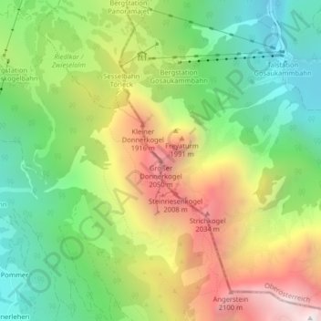
Name: Großer Donnerkogel topographic map, elevation, terrain.
Location: Großer Donnerkogel, Gosau, Bezirk Gmunden, 4824, Österreich (47.52423 13.48133 47.52433 13.48143)
Average elevation: 1,442 m
Minimum elevation: 879 m
Maximum elevation: 2,226 m
Other topographic maps
Click on a map to view its topography, its elevation and its terrain.
Hintertal
Österreich > Bezirk Gmunden > Gosau
Hintertal, Gosau, Bezirk Gmunden, 4824, Österreich
Average elevation: 1,088 m