
Thank you for supporting this site ❤️
Make a donation
Make a donation
Harveng topographic map
Click on the map to display elevation.
Thank you for supporting this site ❤️
Make a donation
Make a donation
About this map
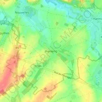
Name: Harveng topographic map, elevation, terrain.
Location: Harveng, Mons, Hainaut, Wallonie, 7022, Belgique (50.37490 3.96688 50.41490 4.00688)
Average elevation: 62 m
Minimum elevation: 37 m
Maximum elevation: 97 m
Thank you for supporting this site ❤️
Make a donation
Make a donation
Other topographic maps
Click on a map to view its topography, its elevation and its terrain.