
Thank you for supporting this site ❤️
Make a donation
Make a donation
Custo topographic map
Click on the map to display elevation.
Thank you for supporting this site ❤️
Make a donation
Make a donation
About this map
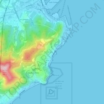
Name: Custo topographic map, elevation, terrain.
Location: Custo, Bergeggi, Savona, Liguria, 17047, Italia (44.22966 8.42542 44.26966 8.46542)
Average elevation: 57 m
Minimum elevation: -2 m
Maximum elevation: 423 m
Thank you for supporting this site ❤️
Make a donation
Make a donation
Other topographic maps
Click on a map to view its topography, its elevation and its terrain.