
Thank you for supporting this site ❤️
Make a donation
Make a donation
Calhoun County topographic map
Click on the map to display elevation.
Thank you for supporting this site ❤️
Make a donation
Make a donation
About this map
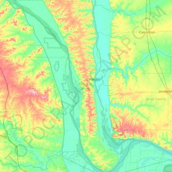
Name: Calhoun County topographic map, elevation, terrain.
Location: Calhoun County, Illinois, United States (38.86829 -90.93722 39.40047 -90.45034)
Average elevation: 169 m
Minimum elevation: 123 m
Maximum elevation: 297 m
Thank you for supporting this site ❤️
Make a donation
Make a donation
Other topographic maps
Click on a map to view its topography, its elevation and its terrain.
Sturbridge Village
United States > Illinois > Winnebago County > Sturbridge Village
Average elevation: 230 m
Thank you for supporting this site ❤️
Make a donation
Make a donation