
Make a donation
Villefranche-sur-Mer topographic map
Click on the map to display elevation.
Make a donation
Villefranche-sur-Mer
The city limits extend to the hills surrounding the bay climbing from sea level to an altitude of 1,893 feet (577 m), the highest point of Mont-Leuze, reflecting on land the features found offshore. The Basse Corniche runs through Vlllefranche with the Moyenne Corniche above and the Haute Corniche above that entering the farthest reach to the west of the Alpes-Maritimes.
Make a donation
About this map
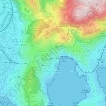
Name: Villefranche-sur-Mer topographic map, elevation, terrain.
Average elevation: 146 m
Minimum elevation: -1 m
Maximum elevation: 560 m
Make a donation
Other topographic maps
Click on a map to view its topography, its elevation and its terrain.
Cime de la Bonette
France > Provence-Alpes-Côte d'Azur > Maritime Alps > Saint-Dalmas-le-Selvage
Average elevation: 2,512 m
Pont du Loup
France > Provence-Alpes-Côte d'Azur > Maritime Alps > Tourrettes-sur-Loup
Average elevation: 607 m
Make a donation
Forte Colle Alto
France > Provence-Alpes-Côte d'Azur > Maritime Alps > Tende
Average elevation: 1,688 m
Roya
France > Provence-Alpes-Côte d'Azur > Maritime Alps > Saint-Étienne-de-Tinée > Roya
Average elevation: 1,857 m
Make a donation
Berghe Inférieur
France > Provence-Alpes-Côte d'Azur > Maritime Alps > Fontan
Average elevation: 963 m
Make a donation
Les Galants
France > Provence-Alpes-Côte d'Azur > Maritime Alps > Escragnolles
Average elevation: 1,158 m