
Make a donation
Służewiec topographic map
Click on the map to display elevation.
Make a donation
About this map
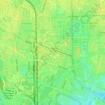
Name: Służewiec topographic map, elevation, terrain.
Location: Służewiec, Mokotów, Warsaw, Masovian Voivodeship, Poland (52.16930 20.98650 52.18955 21.00241)
Average elevation: 108 m
Minimum elevation: 96 m
Maximum elevation: 114 m
Make a donation
Other topographic maps
Click on a map to view its topography, its elevation and its terrain.
Warsaw
Poland > Masovian Voivodeship > Warsaw
Warsaw lies in east-central Poland about 300 kilometres (190 mi) from the Carpathian Mountains and about 260 kilometres (160 mi) from the Baltic Sea, 523 kilometres (325 mi) east of Berlin, Germany. The city straddles the Vistula River. It is located in the heartland of the Masovian Plain, and its average…
Average elevation: 95 m
Warsaw
Poland > Masovian Voivodeship > Warsaw
Warsaw lies in east-central Poland about 300 km (190 mi) from the Carpathian Mountains and about 260 km (160 mi) from the Baltic Sea, 523 km (325 mi) east of Berlin, Germany. The city straddles the Vistula River. It is located in the heartland of the Masovian Plain, and its average elevation is 100 m (330 ft)…
Average elevation: 95 m
Warsaw
Poland > Masovian Voivodeship > Warsaw
Warsaw lies in east-central Poland about 300 kilometres (190 mi) from the Carpathian Mountains and about 260 kilometres (160 mi) from the Baltic Sea, 523 kilometres (325 mi) east of Berlin, Germany. The city straddles the Vistula River. It is located in the heartland of the Masovian Plain, and its average…
Average elevation: 95 m
Warsaw
Poland > Masovian Voivodeship > Warsaw
Warsaw lies in east-central Poland about 300 km (190 mi) from the Carpathian Mountains and about 260 km (160 mi) from the Baltic Sea, 523 km (325 mi) east of Berlin, Germany. The city straddles the Vistula River. It is located in the heartland of the Masovian Plain, and its average elevation is 100 m (330 ft)…
Average elevation: 95 m
Make a donation
Warsaw
Poland > Masovian Voivodeship > Warsaw
Warsaw lies in east-central Poland about 300 km (190 mi) from the Carpathian Mountains and about 260 km (160 mi) from the Baltic Sea, 523 km (325 mi) east of Berlin, Germany. The city straddles the Vistula River. It is located in the heartland of the Masovian Plain, and its average elevation is 100 m (330 ft)…
Average elevation: 95 m