
Thank you for supporting this site ❤️
Make a donation
Make a donation
Löllinghausen topographic map
Click on the map to display elevation.
Thank you for supporting this site ❤️
Make a donation
Make a donation
About this map
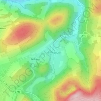
Name: Löllinghausen topographic map, elevation, terrain.
Average elevation: 410 m
Minimum elevation: 290 m
Maximum elevation: 584 m
Thank you for supporting this site ❤️
Make a donation
Make a donation
Other topographic maps
Click on a map to view its topography, its elevation and its terrain.
Remblinghausen
Duitsland > Noordrijn-Westfalen > Hochsauerlandkreis > Meschede
Average elevation: 410 m
Thank you for supporting this site ❤️
Make a donation
Make a donation