
Thank you for supporting this site ❤️
Make a donation
Make a donation
San Miguel topographic map
Click on the map to display elevation.
Thank you for supporting this site ❤️
Make a donation
Make a donation
About this map
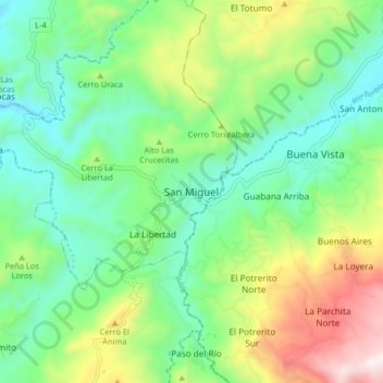
Name: San Miguel topographic map, elevation, terrain.
Average elevation: 1,141 m
Minimum elevation: 829 m
Maximum elevation: 1,811 m
Thank you for supporting this site ❤️
Make a donation
Make a donation
Other topographic maps
Click on a map to view its topography, its elevation and its terrain.
Parroquia Juan Bautista Rodríguez
Venezuela > Estado Lara > Municipio Jiménez
Average elevation: 691 m