Haldwani topographic map
Interactive map
Click on the map to display elevation.
About this map
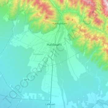
Name: Haldwani topographic map, elevation, terrain.
Location: Haldwani, Nainital District, Uttarakhand, India (29.08483 79.36225 29.29770 79.66641)
Average elevation: 526 m
Minimum elevation: 227 m
Maximum elevation: 2,112 m
Haldwani is located at 29°13′N 79°31′E / 29.22°N 79.52°E / 29.22; 79.52, in the Nainital district on the right bank of the Gaula River. Geologically, Haldwani is settled on a piedmont grade (called Bhabhar) where the mountain rivers go underground to re-emerge in the Indo-Gangetic plain. The Haldwani Bhabhar stretches horizontally, surrounded by the regions of Ramnagar and Tanakpur and lies between the Shivalik hills to the north and the Terai region of Rudrapur to the south. The average land elevation is 424 m (1,391 ft) above sea level. According to the Bureau of Indian Standards, Haldwani falls under seismic zone 4, in a scale of 2 to 5 (in order of increasing vulnerability to earthquakes).
Other topographic maps
Click on a map to view its topography, its elevation and its terrain.
Kedarnath
India > Uttarakhand > Ukhimath
Kedarnath, Ukhimath, Rudraprayag District, Uttarakhand, India
Average elevation: 4,219 m
Lake Vasuki Tal
India > Uttarakhand > Ukhimath > Kedarnath
Lake Vasuki Tal, Kedarnath, Ukhimath, Rudraprayag District, Uttarakhand, India
Average elevation: 4,303 m
Jamroli
India > Uttarakhand > Ghansali
Jamroli, Ghansali, Tehri Garhwal District, Uttarakhand, India
Average elevation: 2,140 m
Yamunotri
India > Uttarakhand > Rajgarhi
Yamunotri, Rajgarhi, Uttarkashi District, Uttarakhand, India
Average elevation: 3,692 m
Joshimath Tehsil
Joshimath Tehsil, Chamoli District, Uttarakhand, India
Average elevation: 4,423 m
Dhumakot
India > Uttarakhand > Dhoomakot
Dhumakot, Dhoomakot, Pauri Garhwal District, Uttarakhand, 246277, India
Average elevation: 1,605 m
Gangotri Glacier
India > Uttarakhand > Bhatwari
Gangotri Glacier, Bhatwari, Uttarkashi District, Uttarakhand, India
Average elevation: 5,259 m
Lambgaon
India > Uttarakhand > Pratapnagar
Lambgaon, Pratapnagar, Tehri Garhwal, Uttarakhand, 249165, India
Average elevation: 1,497 m
Kotdwar
India > Uttarakhand > Kotdwara
Kotdwar, Kotdwara, Pauri Garhwal District, Uttarakhand, 246149, India
Average elevation: 471 m
Retali
India > Uttarakhand > Chamoli Tehsil > Gadora
Retali, Gadora, Chamoli Tehsil, Chamoli district, Uttarakhand, 246472, India
Average elevation: 1,570 m
Joshimath
India > Uttarakhand > Joshimath Tehsil
Joshimath, Joshimath Tehsil, Chamoli district, Uttarakhand, India
Average elevation: 2,272 m
pipalkoti
India > Uttarakhand > Srinagar > Khanda
pipalkoti, Khanda, Srinagar, Pauri Garhwal, Uttarakhand, 249127, India
Average elevation: 885 m
Elephant Pound Rajaji National park Uttrakhand
India > Uttarakhand > Yamkeshwar
Elephant Pound Rajaji National park Uttrakhand, Yamkeshwar, Pauri Garhwal, Uttarakhand, India
Average elevation: 455 m
Gangani
India > Uttarakhand > Rajgarhi
Gangani, Rajgarhi, Uttarkashi district, Uttarakhand, India
Average elevation: 1,551 m
Kinwani
India > Uttarakhand > Narendra Nagar > Narendranagar
Kinwani, Narendranagar, Narendra Nagar, Tehri Garhwal, Uttarakhand, 249175, India
Average elevation: 903 m
pilkhi
India > Uttarakhand > Ghansali
pilkhi, Ghansali, Tehri Garhwal, Uttarakhand, 249181, India
Average elevation: 1,156 m
Ghansali
India > Uttarakhand > Ghansali
Ghansali, Tehri Garhwal, Uttarakhand, India
Average elevation: 1,111 m
Mori
Mori, Uttarkashi district, Uttarakhand, 249128, India
Average elevation: 3,191 m
Dehradun
India > Uttarakhand > Dehradun
Dehradun, Dehradun District, Uttarakhand, 248001, India
Average elevation: 904 m
sujjargaon
India > Uttarakhand > Pratapnagar > Kyari(002)
sujjargaon, Kyari(002), Pratapnagar, Tehri Garhwal, Uttarakhand, 249165, India
Average elevation: 1,479 m
Hardeol
India > Uttarakhand > Joshimath Tehsil
Hardeol, Joshimath Tehsil, Chamoli district, Uttarakhand, India
Average elevation: 6,228 m
Gangolihāt
India > Uttarakhand > Gangolihat
Gangolihāt, Gangolihat, Pithoragarh district, Uttarakhand, 262522, India
Average elevation: 1,532 m
Baniyari
India > Uttarakhand > Rudraprayag > Agastmuni
Baniyari, Agastmuni, Rudraprayag, Uttarakhand, 246421, India
Average elevation: 1,150 m
Uttarkashi
India > Uttarakhand > Bhatwari
Uttarkashi, Bhatwari, Uttarkashi district, Uttarakhand, 249193, India
Average elevation: 1,619 m
Barkot
India > Uttarakhand > Rajgarhi
Barkot, Rajgarhi, Uttarkashi district, Uttarakhand, India
Average elevation: 1,628 m
Khatīma
Khatīma, Udham Singh Nagar, Uttarakhand, 262308, India
Average elevation: 219 m
Laksar
India > Uttarakhand > Laksar > Laksar
Laksar, Haridwar, Uttarakhand, India
Average elevation: 238 m
Jalai
India > Uttarakhand > Ukhimath > Jalai
Jalai, Ukhimath, Rudraprayag, Uttarakhand, 246419, India
Average elevation: 1,311 m
Lansdowne
India > Uttarakhand > Lansdowne
Lansdowne, Pauri Garhwal, Uttarakhand, India
Average elevation: 1,025 m
satkhol
India > Uttarakhand > satkhol
satkhol, Kosya Kutauli, Nainital, Uttarakhand, 263138, India
Average elevation: 1,704 m
Pithoragarh
India > Uttarakhand > Pithoragarh Tehsil
Pithoragarh, Pithoragarh Tehsil, Pithoragarh district, Uttarakhand, 262500, India
Average elevation: 1,617 m
dhanaula
India > Uttarakhand > Dehradun > dhanaula
dhanaula, Dehradun, Uttarakhand, 248009, India
Average elevation: 1,011 m
Mohabbewāla
India > Uttarakhand > Dehradun > Dehradun > Mohabbewāla
Mohabbewāla, Dehradun, Uttarakhand, 248001, India
Average elevation: 626 m
Haridwar
India > Uttarakhand > Hardwar
Haridwar, Hardwar, Haridwar District, Uttarakhand, 249401, India
Average elevation: 360 m
Pindar Glacier
Pindar Glacier, Bageshwar, Uttarakhand, India
Average elevation: 4,447 m
Milam Glacier
Milam Glacier, Pithoragarh, Uttarakhand, India
Average elevation: 5,223 m
Gangotri
India > Uttarakhand > Gangotri
Gangotri, Uttarkashi, Uttarakhand, India
Average elevation: 4,139 m