
Thank you for supporting this site ❤️
Make a donation
Make a donation
Klasov topographic map
Click on the map to display elevation.
Thank you for supporting this site ❤️
Make a donation
Make a donation
Klasov
The village lies at an altitude of 177 metres (581 ft) and covers an area of 12.231 square kilometres (4.722 sq mi). It has a population of about 1,210 people.
Thank you for supporting this site ❤️
Make a donation
Make a donation
About this map
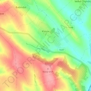
Name: Klasov topographic map, elevation, terrain.
Average elevation: 190 m
Minimum elevation: 143 m
Maximum elevation: 240 m
Thank you for supporting this site ❤️
Make a donation
Make a donation