
Thank you for supporting this site ❤️
Make a donation
Make a donation
Shirenewton topographic map
Click on the map to display elevation.
Thank you for supporting this site ❤️
Make a donation
Make a donation
About this map
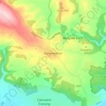
Name: Shirenewton topographic map, elevation, terrain.
Location: Shirenewton, Monmouthshire, Wales, NP16 6RQ, United Kingdom (51.61872 -2.77326 51.65872 -2.73326)
Average elevation: 108 m
Minimum elevation: 15 m
Maximum elevation: 245 m
Thank you for supporting this site ❤️
Make a donation
Make a donation
Other topographic maps
Click on a map to view its topography, its elevation and its terrain.
Thank you for supporting this site ❤️
Make a donation
Make a donation
Thank you for supporting this site ❤️
Make a donation
Make a donation