
Thank you for supporting this site ❤️
Make a donation
Make a donation
Antofagasta topographic map
Click on the map to display elevation.
Thank you for supporting this site ❤️
Make a donation
Make a donation
Antofagasta
The city has an average elevation of 40 m (131 ft).
Thank you for supporting this site ❤️
Make a donation
Make a donation
About this map
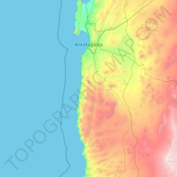
Name: Antofagasta topographic map, elevation, terrain.
Average elevation: 952 m
Minimum elevation: 0 m
Maximum elevation: 4,800 m
Thank you for supporting this site ❤️
Make a donation
Make a donation
Other topographic maps
Click on a map to view its topography, its elevation and its terrain.
Norte Grande
Chile > Antofagasta Region > Provincia de Antofagasta > Sierra Gorda
The desert region is an elevated arid plateau descending gradually from the Andes towards the coast, where it breaks down abruptly from elevations of 800 to 1500 ft. From the sea this plateau escarpment has the appearance of a range of flat topped hills closely following the coast line. This topography…
Average elevation: 2,112 m