
Thank you for supporting this site ❤️
Make a donation
Make a donation
Unterschüpf topographic map
Click on the map to display elevation.
Thank you for supporting this site ❤️
Make a donation
Make a donation
About this map
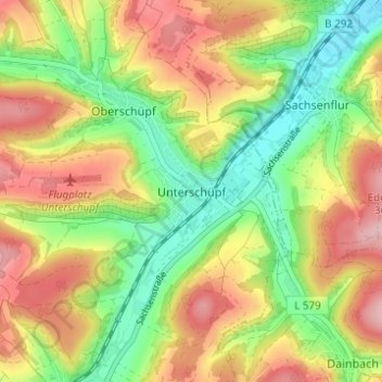
Name: Unterschüpf topographic map, elevation, terrain.
Average elevation: 284 m
Minimum elevation: 199 m
Maximum elevation: 380 m
Thank you for supporting this site ❤️
Make a donation
Make a donation
Other topographic maps
Click on a map to view its topography, its elevation and its terrain.
97944
Deutschland > Baden-Württemberg > Main-Tauber-Kreis > Boxberg > Wölchingen
Average elevation: 343 m
Thank you for supporting this site ❤️
Make a donation
Make a donation