
Talsarnau topographic map
Click on the map to display elevation.
About this map
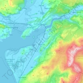
Name: Talsarnau topographic map, elevation, terrain.
Location: Talsarnau, Gwynedd, Wales, United Kingdom (52.87172 -4.16127 52.94172 -3.97763)
Average elevation: 132 m
Minimum elevation: -3 m
Maximum elevation: 611 m
Other topographic maps
Click on a map to view its topography, its elevation and its terrain.
Snowdon
United Kingdom > Wales > Gwynedd
Snowdon (/ˈsnoʊdən/) or Yr Wyddfa (pronounced [ər ˈʊɨ̞̯ðva] (listen)), is the highest mountain in Wales, at an elevation of 1,085 metres (3,560 ft) above sea level, and the highest point in the British Isles outside the Scottish Highlands. It is located in Snowdonia National Park (Parc Cenedlaethol…
Average elevation: 692 m
Cwm Idwal
United Kingdom > Wales > Gwynedd
Cwm Idwal is a cirque (or corrie) in the Glyderau range of mountains in northern Snowdonia, the national park in the mountainous region of North Wales. Its main interest is to hill walkers and rock climbers, but it is also of interest to geologists and naturalists, given its combination of altitude (relatively…
Average elevation: 600 m
Morfa Harlech National Nature Reserve
United Kingdom > Wales > Gwynedd > Harlech
Average elevation: 3 m
Parc Tan-y-Bwlch
United Kingdom > Wales > Gwynedd > Mynydd Llandygái > Pen Y Bwlch
Average elevation: 293 m
Tywyn
United Kingdom > Wales > Gwynedd
In Samuel Lewis's A Topographical Dictionary of Wales (1833) it is reported that popular horse races were held on land to the north of the town every September. Between 1904 and 1947, Towyn Golf Club (originally the Towyn-on-Sea Golf Club) was also located on land to the north of the town.
Average elevation: 50 m