
Thank you for supporting this site ❤️
Make a donation
Make a donation
Elzach topographic map
Click on the map to display elevation.
Thank you for supporting this site ❤️
Make a donation
Make a donation
Elzach
The town of Elzach is located at the eastern border of the district of Emmendingen and borders on the district of the Ortenaukreis and the Schwarzwald-Baar-Kreis. Topographically is the area characterised by the river valley of the Elz and the local hill called Rohrhardsberg. Also Elzach belongs to the Breisgau area and is located at the edge of the Southern Black Forest Nature Park.
Thank you for supporting this site ❤️
Make a donation
Make a donation
About this map
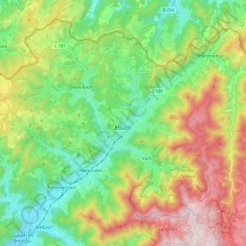
Name: Elzach topographic map, elevation, terrain.
Average elevation: 606 m
Minimum elevation: 282 m
Maximum elevation: 1,171 m
Thank you for supporting this site ❤️
Make a donation
Make a donation
Other topographic maps
Click on a map to view its topography, its elevation and its terrain.