
Thank you for supporting this site ❤️
Make a donation
Make a donation
Ko Pha-ngan topographic map
Click on the map to display elevation.
Thank you for supporting this site ❤️
Make a donation
Make a donation
About this map
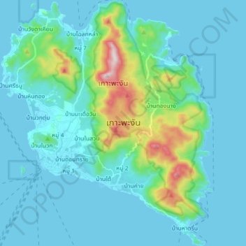
Name: Ko Pha-ngan topographic map, elevation, terrain.
Average elevation: 84 m
Minimum elevation: 0 m
Maximum elevation: 602 m
Thank you for supporting this site ❤️
Make a donation
Make a donation
Other topographic maps
Click on a map to view its topography, its elevation and its terrain.
Mae Haad Cove (Nudist Beach)
Thailand > Ko Pha-ngan District > Baan Wang Ta Kien > Haad Mae Haad
Average elevation: 42 m