
Thank you for supporting this site ❤️
Make a donation
Make a donation
Lake Rosseau topographic map
Click on the map to display elevation.
Thank you for supporting this site ❤️
Make a donation
Make a donation
About this map
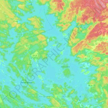
Name: Lake Rosseau topographic map, elevation, terrain.
Average elevation: 251 m
Minimum elevation: 221 m
Maximum elevation: 332 m
Thank you for supporting this site ❤️
Make a donation
Make a donation
Other topographic maps
Click on a map to view its topography, its elevation and its terrain.
Thank you for supporting this site ❤️
Make a donation
Make a donation
Riverdale Island
Canada > Ontario > Muskoka District > Muskoka Lakes Township
Average elevation: 236 m
Thank you for supporting this site ❤️
Make a donation
Make a donation