
Urlau topographic map
Interactive map
Click on the map to display elevation.
About this map
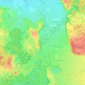
Name: Urlau topographic map, elevation, terrain.
Average elevation: 698 m
Minimum elevation: 667 m
Maximum elevation: 741 m
Other topographic maps
Click on a map to view its topography, its elevation and its terrain.
Unteröschhöfe
Duitsland > Baden-Württemberg > Landkreis Ravensburg > Leutkirch im Allgäu
Unteröschhöfe, Herlazhofen, Leutkirch im Allgäu, Verwaltungsgemeinschaft Leutkirch im Allgäu, Landkreis Ravensburg, Baden-Württemberg, 88299, Duitsland
Average elevation: 697 m
Hofs
Duitsland > Baden-Württemberg > Landkreis Ravensburg > Leutkirch im Allgäu
Hofs, Leutkirch im Allgäu, Verwaltungsgemeinschaft Leutkirch im Allgäu, Landkreis Ravensburg, Baden-Württemberg, 87764, Duitsland
Average elevation: 694 m
Leutkirch
Duitsland > Baden-Württemberg > Landkreis Ravensburg > Leutkirch im Allgäu
Leutkirch, Leutkirch im Allgäu, Verwaltungsgemeinschaft Leutkirch im Allgäu, Landkreis Ravensburg, Baden-Württemberg, 88299, Duitsland
Average elevation: 671 m