
Thank you for supporting this site ❤️
Make a donation
Make a donation
Lau Tepu topographic map
Click on the map to display elevation.
Thank you for supporting this site ❤️
Make a donation
Make a donation
About this map
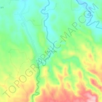
Name: Lau Tepu topographic map, elevation, terrain.
Location: Lau Tepu, Langkat, North Sumatra, Sumatra, Indonesia (3.40455 98.30682 3.44455 98.34682)
Average elevation: 184 m
Minimum elevation: 104 m
Maximum elevation: 315 m
Thank you for supporting this site ❤️
Make a donation
Make a donation