
Thank you for supporting this site ❤️
Make a donation
Make a donation
Valsavignone topographic map
Click on the map to display elevation.
Thank you for supporting this site ❤️
Make a donation
Make a donation
About this map
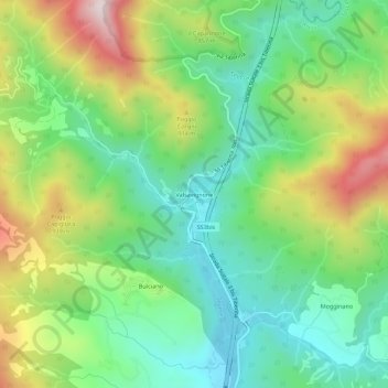
Name: Valsavignone topographic map, elevation, terrain.
Location: Valsavignone, Pieve Santo Stefano, Arezzo, Toscana, Italia (43.71586 12.00522 43.75586 12.04522)
Average elevation: 737 m
Minimum elevation: 510 m
Maximum elevation: 1,149 m
Thank you for supporting this site ❤️
Make a donation
Make a donation
Other topographic maps
Click on a map to view its topography, its elevation and its terrain.
Riserva naturale dell'Alta Valle del Tevere - Monte Nero
Italia > Toscana > Arezzo > Pieve Santo Stefano
Average elevation: 965 m
Thank you for supporting this site ❤️
Make a donation
Make a donation